
University of Oregon research project
The objective of the urban ecological interaction tool was to empower designers to make informed decisions based on the ability to make and relate information. The tool would facilitate relating dissimilar information without combining them by turning on and off the visualization and modifying computation of different aspects of air, water and heat/light data. While the tool may currently show specific design output features of groundscape, vegetation and trees, the tool rather shows a workflow that could also include seating, eating and play surfaces to further engage natural / atmospheric phenomena with social interaction.
A sub-section of investigation was done for each air, water and heat/light. This section will describe the decisions for each study and the individual design output of each.
A. AIR
The inclusion of air qualities intended to make visible to urban designers the differences of air quality within a street and allow that data to directly inform urban design differences within the small spaces of a street. Air quality formulation of input data was used for two design outputs: 1) tree species selection for their ability to sequester certain air pollutants and 2) planter design to accommodate smaller planting vegetation for their ability to both sequester other air pollutants and flowering that provides an interactive design element for people to engage. Air pollutants measured included PM 0.5, PM 2.5, NO and CO. Experiential qualities included small type and intensity. Wind was measured for direction and speed on-site and off-site data included monthly averages to adjust the tool across the year. Noise levels were measure for intensity and diversity of type.
The resulting tool provided a computational output for evenly spaced locations of street trees and human level planting vegetation. Formulation was done in the Rhino Grasshopper environment. That formulation is adaptable within the native Grasshopper environment for different users to make evaluations. The street tree output can vary across a street and intersection. Tradition street tree selection is often one single species as we see in city managed selection today or prescriptive selections by owners using various aesthetic criteria. The research designed street-level planter can vary in height and width using modular elements to support the varied qualities of the computed planting type.
The air pollution sub-section of the overall tool was important because it used data selected by the research team to design the tool. It then used newly collected data on-site and existing data off-site. The new data was certainly only a test dataset. To make conclusive findings from the methodology data collection on-site would have to be repeated, tools calibrated more carefully with certified equipment and observed phenomena such as construction, temperature, humidity and social activities more carefully recorded to ensure they did not adversely affect the data collection. As air pollution research including that of particulate matter and nitrogen oxide are given more focus and as small handheld sensor technology is improving [24], and while urban design strategies such as Superilles differentiate urban space from interior to exterior streets, a computation design approach may effectively connect technology with urban design theory.
WATER
Water qualities were studied to understand the relationship between water use in a street and Superilla area and the opportunity to 1) manage water in various rain events using qualities across streets and 2) provide an everyday urban design experience that allows people to understand these natural and urban phenomena. In the case of this sub-study the design output of paving design did not vary within a street but vary across the streets of the Sueprilla corresponding to respective input variations. Street slope was measured in direction and intensity. Grey water contribution from residents was measured with building use type, building area and number of floors. Soil type was included. Temperature and humidity variations were measured on-site. Formulation was also to understand the rainfall volume in various storm events such as typical rain, heavy rains, storm event and atypical storm event.
The resulting tool provided a computational output for street pavers slope, spacing and orientation. These variations would provide opportunity for water to be filtered and absorbed into the ground soil and diverted from storm water collection. The resulting water capture could provide additional benefits to support vegetation and contribute to the local aquifer. Thresholds for the various rain events can be changed in the tool as well as location and weather data. The resulting variations of the very small pavers suggest the importance of small variations to respond to larger weather events at the scale of the region and city.
The water sub-section of research contributes to the ability to find methods that input data across various scales. At the urban scale within streets data varied by adjacent building use such as residential versus industrial and their corresponding potential grey water contribution. Slope varied only at the scale of the street. Meanwhile soil type for example in Barcelona only varies along one line in the city. Rain fall data is a single data value for the entire city. Thusly the tool was challenged by its reliance on existing data. Small-scale differences other than building use relied on off-site existing data. Still street pavers typically do not vary across districts if not cities. Even a variation across individual street blocks would be a radical proposal for cities but made possible by such a tool.
B. HEAT/LIGHT
The objective of the heat/light sub-section of study was to measure and design around the impact of urban heat island effect at the small-scale differences within streets. Computation for this sub-section of the tool was greatly supported by the Ladybug plugin for Rhino Grasshopper and the radiance dataset. The application is often used for indoor daylighting and radiance analysis but in this case was used to determine the heat absorption at the street-level public space. Initial data collection of ground and air temperature was done on-site however inconsistency from the sensors and via tree canopy led the research to instead use the data from the Ladybug plugin simulation. All buildings for the Superilla were modeled. On-site date for building façade materials was used. Off-site measurements of street width and approximate building height was converted into a ratio and used in the computation.
The design output was analytical information of annual heat island effect based on the buildings, materials and solar orientation and the specific output of street tree location and species selection. A balance of tree canopy size and type was made between abundant shading to reduce heat island effect and ambient light penetration to support street level social activities. Computation also addressed the recent understanding of tree leaf canopy structure that not only shades but allows air pollution to escape. For example, in Barcelona, London plane trees are now thought to trap PM air pollution at the street level. The computational design output of a tool that varies tree species based on adjacent buildings has not been found and one could a rich diversity of tree canopy that slowly evolves either when new construction occurs and or trees die and are replaced.
This sub-tool that measures the small scale of urban heat island effect and light resulted in a rich variation of tree variations within a street. While data collection of phenomena was challenging, the variation of built fabric and the resulting tree species represents a relatively adaptive urban system in the long term urban planning of cities. External radiance and weather data was not locally collected. However, the adaptation to measure individual buildings was a necessary part of this tool and reinforces the value of small-scale data analysis to respond to large scale problems such as urban heat island effect.
C. Tool integration for air, water and heat/light
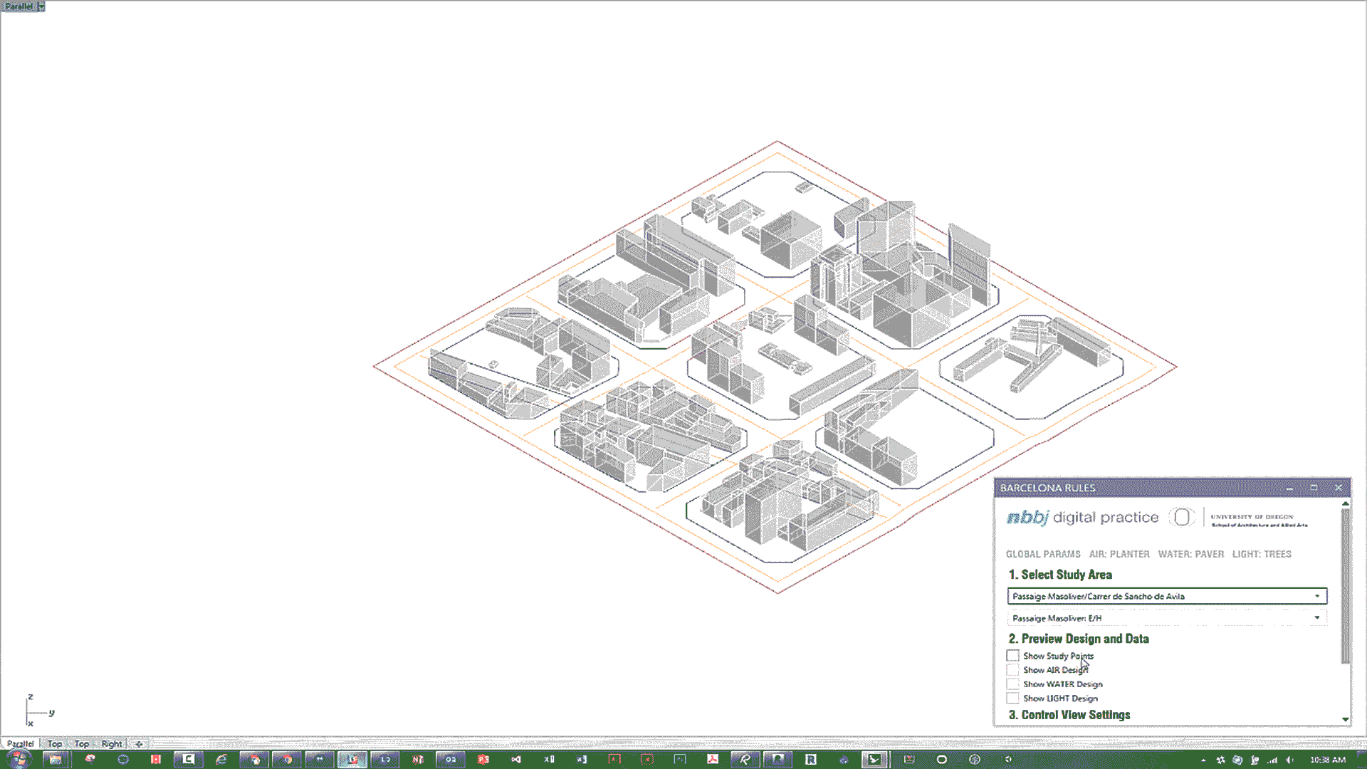
The integration of the air, water and heat/light sub study and sub-tools provided significant challenges. Air and heat/light sub-tools for example both provided a design output for tree species selection. Additionally the visualization of all the varied data requires the active participation of the user to create data visualization that is organized and understandable in the Human User Interface. Despite these challenges the current evolution of the urban ecological tool (figure 11) contributes to the research area since most data of this type at a larger scale. The methodology allows 1) design selection of ecological qualities; 2) custom data collection at the small-scale of streets and experiential urbanism; 3) custom analysis formulation with opportunities for reevaluating relationships and 4) direct computational urban design output at the scale of streets including street trees species and locations, vegetation planters and ground pavers for hydrological performance. Future development of the tool will look for way to more smoothly integrate the design output (figure 12). However, the methodology described here should not be evaluated on the success of the product of integration but on the successful interface of custom data collection and parametric urban design within a traditional context of little urban design variation at this scale that directly using data of natural phenomena.
Speranza, P (2016) “Urban Ecological Interaction: Air, Water, Light and New Transit at the Human Scale of Barcelona's Superilles” Proceedings of 18th International Conference on Advanced Urban Designing and Transportation 2016, ICAUDT, December 12-13, 2016, Barcelona: Spain.
click here to download

Urban Analysis Tool
University of Oregon research project
The objective of the urban ecological interaction tool was to empower designers to make informed decisions based on the ability to make and relate information. The tool would facilitate relating dissimilar information without combining them by turning on and off the visualization and modifying computation of different aspects of air, water and heat/light data. While the tool may currently show specific design output features of groundscape, vegetation and trees, the tool rather shows a workflow that could also include seating, eating and play surfaces to further engage natural / atmospheric phenomena with social interaction.
A sub-section of investigation was done for each air, water and heat/light. This section will describe the decisions for each study and the individual design output of each.
A. AIR
The inclusion of air qualities intended to make visible to urban designers the differences of air quality within a street and allow that data to directly inform urban design differences within the small spaces of a street. Air quality formulation of input data was used for two design outputs: 1) tree species selection for their ability to sequester certain air pollutants and 2) planter design to accommodate smaller planting vegetation for their ability to both sequester other air pollutants and flowering that provides an interactive design element for people to engage. Air pollutants measured included PM 0.5, PM 2.5, NO and CO. Experiential qualities included small type and intensity. Wind was measured for direction and speed on-site and off-site data included monthly averages to adjust the tool across the year. Noise levels were measure for intensity and diversity of type.
The resulting tool provided a computational output for evenly spaced locations of street trees and human level planting vegetation. Formulation was done in the Rhino Grasshopper environment. That formulation is adaptable within the native Grasshopper environment for different users to make evaluations. The street tree output can vary across a street and intersection. Tradition street tree selection is often one single species as we see in city managed selection today or prescriptive selections by owners using various aesthetic criteria. The research designed street-level planter can vary in height and width using modular elements to support the varied qualities of the computed planting type.
The air pollution sub-section of the overall tool was important because it used data selected by the research team to design the tool. It then used newly collected data on-site and existing data off-site. The new data was certainly only a test dataset. To make conclusive findings from the methodology data collection on-site would have to be repeated, tools calibrated more carefully with certified equipment and observed phenomena such as construction, temperature, humidity and social activities more carefully recorded to ensure they did not adversely affect the data collection. As air pollution research including that of particulate matter and nitrogen oxide are given more focus and as small handheld sensor technology is improving [24], and while urban design strategies such as Superilles differentiate urban space from interior to exterior streets, a computation design approach may effectively connect technology with urban design theory.
WATER
Water qualities were studied to understand the relationship between water use in a street and Superilla area and the opportunity to 1) manage water in various rain events using qualities across streets and 2) provide an everyday urban design experience that allows people to understand these natural and urban phenomena. In the case of this sub-study the design output of paving design did not vary within a street but vary across the streets of the Sueprilla corresponding to respective input variations. Street slope was measured in direction and intensity. Grey water contribution from residents was measured with building use type, building area and number of floors. Soil type was included. Temperature and humidity variations were measured on-site. Formulation was also to understand the rainfall volume in various storm events such as typical rain, heavy rains, storm event and atypical storm event.
The resulting tool provided a computational output for street pavers slope, spacing and orientation. These variations would provide opportunity for water to be filtered and absorbed into the ground soil and diverted from storm water collection. The resulting water capture could provide additional benefits to support vegetation and contribute to the local aquifer. Thresholds for the various rain events can be changed in the tool as well as location and weather data. The resulting variations of the very small pavers suggest the importance of small variations to respond to larger weather events at the scale of the region and city.
The water sub-section of research contributes to the ability to find methods that input data across various scales. At the urban scale within streets data varied by adjacent building use such as residential versus industrial and their corresponding potential grey water contribution. Slope varied only at the scale of the street. Meanwhile soil type for example in Barcelona only varies along one line in the city. Rain fall data is a single data value for the entire city. Thusly the tool was challenged by its reliance on existing data. Small-scale differences other than building use relied on off-site existing data. Still street pavers typically do not vary across districts if not cities. Even a variation across individual street blocks would be a radical proposal for cities but made possible by such a tool.
B. HEAT/LIGHT
The objective of the heat/light sub-section of study was to measure and design around the impact of urban heat island effect at the small-scale differences within streets. Computation for this sub-section of the tool was greatly supported by the Ladybug plugin for Rhino Grasshopper and the radiance dataset. The application is often used for indoor daylighting and radiance analysis but in this case was used to determine the heat absorption at the street-level public space. Initial data collection of ground and air temperature was done on-site however inconsistency from the sensors and via tree canopy led the research to instead use the data from the Ladybug plugin simulation. All buildings for the Superilla were modeled. On-site date for building façade materials was used. Off-site measurements of street width and approximate building height was converted into a ratio and used in the computation.
The design output was analytical information of annual heat island effect based on the buildings, materials and solar orientation and the specific output of street tree location and species selection. A balance of tree canopy size and type was made between abundant shading to reduce heat island effect and ambient light penetration to support street level social activities. Computation also addressed the recent understanding of tree leaf canopy structure that not only shades but allows air pollution to escape. For example, in Barcelona, London plane trees are now thought to trap PM air pollution at the street level. The computational design output of a tool that varies tree species based on adjacent buildings has not been found and one could a rich diversity of tree canopy that slowly evolves either when new construction occurs and or trees die and are replaced.
This sub-tool that measures the small scale of urban heat island effect and light resulted in a rich variation of tree variations within a street. While data collection of phenomena was challenging, the variation of built fabric and the resulting tree species represents a relatively adaptive urban system in the long term urban planning of cities. External radiance and weather data was not locally collected. However, the adaptation to measure individual buildings was a necessary part of this tool and reinforces the value of small-scale data analysis to respond to large scale problems such as urban heat island effect.
C. Tool integration for air, water and heat/light
The integration of the air, water and heat/light sub study and sub-tools provided significant challenges. Air and heat/light sub-tools for example both provided a design output for tree species selection. Additionally the visualization of all the varied data requires the active participation of the user to create data visualization that is organized and understandable in the Human User Interface. Despite these challenges the current evolution of the urban ecological tool (figure 11) contributes to the research area since most data of this type at a larger scale. The methodology allows 1) design selection of ecological qualities; 2) custom data collection at the small-scale of streets and experiential urbanism; 3) custom analysis formulation with opportunities for reevaluating relationships and 4) direct computational urban design output at the scale of streets including street trees species and locations, vegetation planters and ground pavers for hydrological performance. Future development of the tool will look for way to more smoothly integrate the design output (figure 12). However, the methodology described here should not be evaluated on the success of the product of integration but on the successful interface of custom data collection and parametric urban design within a traditional context of little urban design variation at this scale that directly using data of natural phenomena.
Speranza, P (2016) “Urban Ecological Interaction: Air, Water, Light and New Transit at the Human Scale of Barcelona's Superilles” Proceedings of 18th International Conference on Advanced Urban Designing and Transportation 2016, ICAUDT, December 12-13, 2016, Barcelona: Spain.
click here to download